This page contains all notes of the Aviation Law course.
Exam passed on February 9 2026.
For a live overview of my flight lessons, visit: https://flighttools.justinverstijnen.nl/flightlessontracker
This page can contain a collection of personal notes, steps to remember, finished and unfinished content. Please excuse brevity.
Do not use specific information given like fuel flow, landing/take-off distances for your flights. Always refer to the POH of your exact plane for flight preparation. My information is just for references that I used.
Table of Contents
- Aviation rules and laws in the Netherlands (1)
- Treaty of Chicago and ICAO (2)
- Aircraft (3)
- Aviation Traffic Rules (4)
- Flight Rules Collections
- General flying guidelines
- General ground guidelines
- General Circuit guidelines
- VMC minima
- Flying VFR in CTRs
- VFR limitations
- Flying VFR at night
- Day and night period
- Minimum VFR altitude
- Signals
- Marshalling signs
- Unlawful Interference
- Intercepting civil aircraft (by military)
- Air Traffic Control (5)
- Aerodromes (6)
- Air Traffic Control in-depth (7)
- Pilot licenses (8)
- Flight Preparation and execution (9)
- Operational procedures (10)
- Search and Rescue (11)
- Notes to self for preparation
📖 Estimated read time: 44 minutes
🔄 Page last updated on: February 9, 2026 🆔 Post ID: 5007Aviation rules and laws in the Netherlands (1)
Because the whole world uses aviation to get from A to B, the world needed an organization that will monitor, review and publishes rules for aviation. This is the International Civil Aviation Organization (ICAO), founded in Chicago in 1944. The primary rule was to standardize aviation around the world.
In the Netherlands we have the so called “Wet Luchtvaart” (Aviation Law) and contains all the basics of ICAO themselves, changed for this country. This contains mostly some minor changes from the EU laws.
Treaty of Chicago and ICAO (2)
From the 1944 conference, ICAO was founded and almost all countries around the world are member of this. ICAO publishes guidelines and advisories for countries to adopt to ensure safety but countries are not required to do so. EASA in Europe is an other story, that are laws that all European countries must follow.
- ICAO publishes advisories and recommendations
- EASA publishes laws that are required to follow by the pilot in command
The goal of this conference was to found an organization, ICAO, that creates standardized rules which all pilot in commands around the world must adhere to. From this conference there was signed the Treaty of Chicago which contains a huge load of rules in Annexes, which are attachments to the treaty:
| Annex number | Description |
| Annex 1 | Personnel Licensing |
| Annex 2 | Rules of the Air |
| Annex 3 | Meteorological Service for International Air Navigation |
| Annex 4 | Aeronautical Charts |
| Annex 5 | Units of Measurement to be Used in Air and Ground Operations |
| Annex 6 | Operation of Aircraft |
| Annex 7 | Aircraft Nationality and Registration Marks |
| Annex 8 | Airworthiness of Aircraft |
| Annex 9 | Facilitation |
| Annex 10 | Aeronautical Telecommunications |
| Annex 11 | Air Traffic Services |
| Annex 12 | Search and Rescue |
| Annex 13 | Aircraft Accident and Incident Investigation |
| Annex 14 | Aerodromes |
| Annex 15 | Aeronautical Information Services |
| Annex 16 | Environmental Protection |
| Annex 17 | Security and Unlawful Interference |
| Annex 18 | Transport of Dangerous Goods |
| Annex 19 | Safety Management |
Ground area and sovereign countries
The treaty explains that every country has full control over their own ground area and the air above the ground. It also explains that the water around countries are member of that country, at least within 12 nautical miles (22km) from the coast. Within those 12 nautical miles, the country is responsible for closing the airspace and control it by monitoring and giving clearances.
Access to airspaces
The treaty explains that the participating countries will permit access for uncontrolled flights like from private pilots without landing in the country. This is called the freedom of the air, which gives you the right to cross airspace from another country, with a possibility to make a diversion or emergency landing. This also gives commercial freedom, like transferring passengers or goods to another country.
However, the country where you land can determine if your cargo must be checked or forbid certain goods to ship into the country. Here the country where you land has the lead, because of the sovereignity. They can also forbid, or lead you to a different route in case of emergencies or international emergencies (like war).
A country can also force you to land in their country if they want to check your passengers or cargo. This is called a Safety Assessment of Foreign Aircraft (SAFA) check.
Uniformity of aviation rules
All participants of aviation of the treaty are required to comply with as much rules as possible of the treaty. These rules are described in Annex 2. The best thing is that the whole world uses the same rules, but some countries are more strict than other countries, especially the USA as a result of the 9/11 attacks.
Customs and immigration
A plane can be used to transfer cargo and passengers, so the customs of a departing and landing country must use an airfield with customs, which will check if everything is following the rules. You may only plan to fly an international flight when departing from an international airfield.
The treaty of Chicago states that aircraft can be allowed in a country without paying customs or other costs for fuel, oil, spare parts and extra stuff. This would make it impossible as every country has their own rules for taxes and importing goods.
It can also be required for international flights to submit a General Declaration. This requirement is mostly when flying outside of the Schengen-zone, incoming or outgoing.
Required documents on board
On every flight it is required to have these documents on board:
- Certificate of Airworthiness
- Pilot License / Certificate of the pilots given by country (or EU) of aircraft registration (ICAO-confirmed, RPL and LAPL not included)
- Journal
Radios and technology
The board devices of the plane must comply with the minimum requirements of the country where the plane is registered. When using the devices, the rules of the country below the plane apply.
For the radio’s, only qualified personnel that have a RT certificate may send over the radio.
Cameras
Countries can forbid you to use cameras on board of aircraft. In most countries, there are restrictions on making pictures of military facilities. In the Netherlands, there was a very restricting law that forbid most of the pictures from the air, but was suspended in 2013.
Aircraft (3)
All aircraft must be registered in the national aviation register and will receive a registration number. This number must be short, but with the most combinations possible.
In the Netherlands, this is done by the “Inspectie Leefomgeving en Transport” (ILT).
Registration numbers will be made up in two parts:
- Country/Nationality code – Registration mark
Some examples will be:
- PH-JSV
- OE-HWN
- PH-1234
Every country has it’s own code, which you can find here: https://www.avcodes.co.uk/regprefixcur.asp
Here is an example of the registration numbers and method in the Netherlands:
| Aircraft type | Naming Convention | Example |
| Planes, Helicopters and Hot air balloons | 3 letters | PH-JSV |
| TMG’s and Gliders | 3 or 4 numbers | PH-2653 |
| Microlight aircraft | Number-Letter-Number | PH-6H9 |
| Unattended aircraft (Drones) | Number-Letter-Letter | PH-8SD |
The registration number is like a license plate for a car. A unique number, instead of “A red or yellow plane”. There are some requirements for this number to be visible:
- Both sides on the wing or tail (visible from Air)
- Both sides at the underside of the wings (visible from ground)
There are some specific guidelines for visibility
- Registration number must be 50 centimeters high on the fuselage
- Registration number must be 30 centimeters on the vertical stabilizer
- It must be clear and readable from several hundred meters distance
Aviation Traffic Rules (4)
Most of the rules in the EU about aviation are described in the Standardised European Rules of the Air (SERA), or called No 923/2012 which can be found here: https://eur-lex.europa.eu/eli/reg_impl/2012/923/oj/eng
Countries can deviate from these rules but must align with the rules described in the SERA as baseline.
In an aircraft, the Pilot in Command is responsable for a flight following the rules. Violation of rules is only permitted in emergency situations.
Flight Rules Collections
For types of flights, we have 2 collections of rules:
- Visual Flight Rules (VFR): Flying on visual checkpoints and POI’s
- Instrument Flight Rules (IFR): Flying on instruments/navigational waypoints
Commercial flights will always fly on IFR to reduce the workload of the captains. Also, they very often have to fly through cloud layers where flying visually is not possible.
General flying guidelines
We have some general guidelines for flying in the air. These rules are based on:
- Corrections on earlier mistakes/incidents/crashes
- Safety
- Minimizing pilot input
- Throwing items from the plane is not permitted
- Simulating IFR in a not IFR ready environment
- Avoid collisions. Formation flights only permitted when its a controlled flight
- Priority rules, traffic from the right has priority
- Two planes that fly right head on must deviate to the right to avoid collision
- Overtaking must be done over the right side, under a 70 degrees angle of the overtaken plane
There are some special events that could happen:
- Gliders must avoid hot air balloons
- Planes must avoid hot air balloons and gliders (they are the one that have the most control)
General ground guidelines
- Pedestrians and cars must give way for (towed) aircraft
- Emergency vehicles have priority to every other traffic on the ground
- Starting aircraft have priority over taxing aircraft
- Taxiing aircraft must steer to the right to pass each other without collisions (pilot is on the left)
- Crossing roads gives priority to right traffic
- Use as much space as possible when overtaking aircraft on the ground
General Circuit guidelines
When flying a circuit around an aerodrome or airport, these rules apply:
- Injecting the circuit must happen on the signal aera (or else when permitted by ATC)
- The circuit must be followed, stay within the borders
- Go arounds must be done safely
- Exiting the circuit must be done at the given position and under an angle of 45 degrees
- Follow deviations in circuit procedures (always check published procedures by AD/airport)
- Controlled airfields has a complete circuit at 1000ft, uncontrolled mostly on 700ft (or else published)
VMC minima
To fly VFR, flight conditions must be at least the rules below:
- 10.000ft/FL100+: 8000 meters or better visibility and 1500 meters horizontal and 1000ft vertical from clouds
- 3000 to 10.000ft: 5000 meters or better visibility and 1500 meters horizontal and 1000ft vertical from clouds
- On or below 3000ft: 5000 meters or better visibility, clear from clouds and view on ground or water
In airspace classes F and G, its allowed to reduce the required visibility below 3000ft. In these special conditions, you may fly with 1500 meters visibility:
- 140 knots or less speed
- Very small chance of meeting other traffic
Flying VFR in CTRs
When flying VFR in CTRs, you must follow these rules:
- The cloud ceiling is 1500ft or higher, or less than 4/8 octas (SCT)
- Ground visibility is 5000 meters or higher
VFR limitations
When flying VFR, you have the following limitations:
- Flying in airspace class A without clearance
- Above FL 195 (19500ft pressure altitude)
- At night without Night VFR rating
- Faster than 530 knots GS
- In airspace classes C to G below FL100 and faster than 250 knots IAS
Flying VFR at night
When you want to fly VFR at night, you must comply with these rules:
- Cloud ceiling must be higher than 1500ft or lower than 4/8 ctas (SCT)
- Visibility in airspace classes F and G on or below 3000ft is at least 5000 meters
- On or below 3000ft AMSL (or 1000AGL if higher) there must be visual on the ground in all airspace classes
- In mountain rich areas, VFR minima will be more strictly than written down here
Day and night period
To define hen its day and night, we have the following rules:
- Its night between the end of civil twilight and the start of morning dusk
- Its civil twilight and dusk when the sun is less than 6 degrees under the horizon, which is around 30-45 minutes after sunrise/sunset
Some countries, like the Netherlands, have a defined “Uniform Daylight Period” (UDP), which defines the start of sunrise and end of sunset on average for the whole country. This is published in the AIP.
Minimum VFR altitude
When flying VFR, you must comply with these altitude rules:
- Above cities or buildings with an altitude to not bother people, but high enough to make an emergency landing (1000ft above the highest building)
- At night: 1000ft above the highest building in a vicinity of 8000 meters or 2000ft in mountain rich areas
You may only defer from these VFR minimums when performing these actions:
- Take-off and landing
- Picking or delivering towing operations
- If any special clearance is given, for example to practice forced landings
Signals
Distress situations
Of course we hope to never need this part of information, but it’s crucial to know. What to do in distress situations, which are the most dangerous, where life is on the gamble.
When an aircraft is in immediate danger, the following steps must be done as pilot in command:
- Transmitting, on the frequency the aircraft is, MAYDAY,MAYDAY,MAYDAY followed by a message that states the callsign current position, heading, altitude, type of disaster and intentions
- Setting the transponder to 7700 (seven, going to heaven).
- Shooting red flares into the air
An aircraft that is in danger is allowed to do everything just to get attention. If this includes a low fly by or calling the LVNL (in the Netherlands) by phone, this is allowed.
The number of the LVNL which could be called in case of emergencies is: 020 406 3999 (source: https://www.lvnl.nl/contact#anchor-d1e22f2a46cf4e81b142c96f01eb99ce).
Emergency situations
In the case of an emergency situation, which is where an aircraft needs priority but not immediate landing, instead of MAYDAY we use the phrase PAN PAN, PAN PAN, PAN PAN. Stating that we need priority caused by an error on board, smoke of strange smell or a person getting sick or incapacitated.
- Just like the distress, start transmitting PAN PAN, PAN PAN, PAN PAN followed by a message that states the callsign current position, heading, altitude, type of disaster and intentions
- When the radio is not working of your aircraft, you can just go through with your flight and try to call the LVNL emergencies number. Also first transmit your message twice when stating “TRANSMITTING BLIND DUE TO RECEIVER FAILURE *message*” like stated here: https://justinverstijnen.nl/flight-rt-course-notes/#frequencies-and-radio-explained
Dangerous or restricted area
When flying into a danger zone or restricted area, its possible that you get some radio calls to defer your course. Its also possible that flares in red and green colors (every 10 seconds) are shooting into the sky where people on the ground warn you about the possible danger you are to encounter. You as pilot in command should always leave the area as quickly as possible. If this takes a 180 turn, do that.
Signals at aerodromes (visual messages)
Its possible if the aerodrome thinks your radio isnt working, that you get visual messages when in the circuit. This can be confirmed if you don’t hear anything on the radio like a response to your message.
The visual messages are also stated in the COM course, and therefore a link to that section:
Some clear notes to remember them good:
- White means clear to land or return to starting point
- Steady green is a clearance to take-off or land
- Steady red means stay where you are or keep circling
- Flashing green means cleared to taxt or return for landing
- Flashing red means expedite, vacate runway or aerodrome unsafe, do not land
To confirm messages given visually, you need to make clear that you saw, understand and performing them. This can be done:
- In daylight, swinging your wings left and right
- In daylight on the ground, moving your rudder full left and full right
- At night or dawn: flash your landing light 2 times or if not possible do other lights like strobe or navigation.
Ground signals
If any radio failure occurs on an aerodrome or aircraft, the aerodrome will put some ground signs at a certain place. This can be at the runway itself.
Here is an overview of the different signs you could encounter. They are also described on the back of the VFR chart.
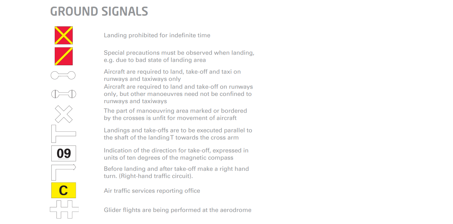
These signals are physically on a large banner which the aerodrome has to put at a certain place in case of emergencies. Physical and visual does always work.
Marshalling signs
At an airport, there is a chance that a marshal will give you instructions about what to do. This will mostly only happen at controlled airfields.

Some additions to the signs that can be given by marshalls:
- Stopping and turning signs are given with his arms. The faster his gesture, the faster you must stop or turn.
- Braking is gestured by the marshall making a fist. Stop braking is the complete opposite gesture.
- Start engine: The marshall will point at the engine that can be started. In most cases with VFR flying, this is only one engine.
Unlawful Interference
In case of unlawful interference, we mean that the aircraft is interfered. This can be a hijack or weaponized aircraft where people in or outside of the aircraft can be in danger. You as pilot in command are asked to do the following actions (if possible of course):
- Notify local aera by radio
- Set 7500 on transponder (five, man with a knife)
- Land as soon as practical at the nearest airfield or keep your current altitude and heading
- Make a emergency notification at the international emergency frequency: 121.500 MHz and keep notifying about heading/altitude differences.
Intercepting civil aircraft (by military)
If an aircraft does not comply with rules, for example flying in a restricted area, the aircraft can be identified, call out or intercepted by the military. In the worst case scenario, there will be a fighter jet flying next to you to check what you are up to.
In this situations, do the following steps:
- Notify your current frequency about this happening
- Set transponder 7700 or other code when asked
- Set radio to 121.500 MHz to communicate with a possible fighter jet next to you
- You have to do everything you are told at this point
- If not possible to communicate because of an language barrier, the following ICAO phrases will be used
| Phrase | Meaning |
| Callsign | Your callsign is? |
| Descend | Descend to land |
| Follow | Follow me |
| You land | Land on this airfield |
| Proceed | You can proceed your flight |
Based on the situation, its possible to answer the actions:
| Phrase | Meaning |
| Callsign | My callsign is … |
| Wilco | Roger, I will follow your instructions |
| Unable | I am unable to follow your instructions |
| Repeat | Please repeat your instructions |
| Am lost | I am lost or no GPS fix |
| Mayday | I am distress traffic |
| Hijack | I am hijacked and possible need some help |
| Land | I am asked to land on … |
| Descend | I have to descend to … ft. |
The fighter jet can also give some visual instructions:

Air Traffic Control (5)
Air Traffic Control (ATC) is for the highest safety possible when flying an aircraft. Because ATC has an overview of all aircraft, their task is to make it safe for everyone by separating aircraft from each other, leading them to certain points etc.
The full list of tasks of ATC:
- Prevnting collisions between aircraft
- Prevention collisions with obstacles
- Enhancing traffic flow
- Giving advices for an safe and efficient flow
- Notifying responsible organizations and helping them
There are 3 types of air traffic service:
- Air Traffic Control for airspaces A, B, C
- Flight Information Services, like Dutch Mil Info or Amsterdam Info
- Alerting service for avoiding possible collisions
The structure of services and their responsibilities is shown on page 44. ¥
Flight Information Regions (FIR)
All airspace parts are together managed by a Flight Information Region (FIR). This is separated for horizontal areas, like the Netherlands is member of the Amsterdam FIR. Belgium is member of the Brussels FIR and so on.
A FIR is a region where all three types of air traffic services take place. Bigger countries like France and Germany have multiple FIRs (4 to 5) to separate the workload.
Air Space Partitions
On page 44 is described that there are multiple manners of separating airspace next to A to G. This must be researched. ¥
Dutch Airspace (as example)
On page 45 there is also a vertical view of the Schiphol (EHAM) CTR, please review thoroughly. ¥
Some simple rules apply for the Dutch airspace:
- From ground to 1500ft, airspace is always G with the exception of CTRs
- A CTR for civil airports is always airspace class C
- A CTR for military airports is always airspace class D
- CTRs in the Netherlands start from the ground and stop at 3000ft AMSL
- Above and outside CTRs we have TMA area’s which are Terminal Maneuvering Areas. This can be seen as approach traffic. Their airspace class defers based on the goal and application.
- Amsterdam has a CTA above the TMA. VFR flights are not permitted in this area and is from FL95 to FL195.
- Amsterdam has a Upper Control Area which spans from FL195 to the ceiling, but good luck getting a Cessna 172 above 19.500ft 🙂
This is all page 45.
Air Traffic Control areas
Air Traffic Control areas are as the name suggests, areas where ATC provides control to your aircraft. This happens mostly with IFR flight rules.
Air Traffic Control areaa are:
- Area Control Center (ACC) (for example: Amsterdam Center) – Leads aircraft in their region from A to B
- Approach Control Unit (APP) (for example: Schiphol Approach) – Leads traffic to the destinated approach path for inbound aircraft
- Aerodrome Control Tower (TWR) (for example: Schiphol Tower) – Leads aircraft to a runway and gives landing clearance
Airspace classes
Same explaination as already done, search for the complete table for a copy. ¥ (Page 47).
Airspace classes can also be temporary active. Always refer to the NOTAMs when planning a flight to be sure you are allowed and flying in the airspace you are supposed to be.
VFR rules and Air Traffic Control
VFR flights are mostly uncontrolled, but in some cases they will be leaded by Air Traffic Control:
- VFR flights in air space classes A, B, C and D.
- Special VFR flights
- VFR flights departing or landing at controlled airfields
A highly advisable note: being controlled by the tower doesnt nessecarily mean that you are being separated from other IFR or VFR traffic. Please refer to the air space classes definitions. (Page 49).
Flight Information Services
In uncontrolled airspace, like E to G, its highly advisable to sign into the Flight Information Services. These will give you important information like:
- Meteorological information like significant or unforecasted weather (SIGMET/AIRMET) or at your destination airport
- Regional QNH, to have all planes in the region flying on the same pressure altitude. This may not be the actual pressure but is an average for the whole region
- Information about navigation tools
- Information about aerodromes (busy or landing not possible)
- Traffic information to avoid collisions (best effort of FIS)
- VFR-unwanted weather reports
- Military operations (like a NAVO Top)
- Other important information for helping you having a great flight
In the Netherlands, we have two Flight Information Services:
- Amsterdam Info for randstad: 124.300 MHz
- Dutch Mil Info for the rest of the Netherlands: 132.350 MHz
You always have to sign in to FIS by describing your flight:
- Dutch Mil Info, PH-JSV
- PH-JSV
- Overhead Apeldoorn
- 1500ft
- VFR to Eelde
- Request flight information services
They will respond with a message to maintain your flight, important information and a regional QNH which you must set. Sometimes they give you a special Transponder code.
Aerodromes (6)
In the Dutch LAW, we have two separate laws for aerodromes:
- Besluit Burgerluchthavens (2009)
- Regeling Veilig gebruik luchthavens en andere terreinen (2009)
Its required to always use airports for take-off and landing. The only exception is when in a distress/emergency situation and you have to do a forced landing.
Gliders and hot air balloons are allowed to take-off and land from any land that is applicable. The same applies for police or emergency choppers.
Civil aviation is forbidden to use military airports, except if they have a special clearance.
Position of an aerodrome
The podition of an aerodrome is fixed by a clear GPS point, called the Aerodrome Reference Point (ARP) and is mostly the geometric center of the aerodrome. This will never change in normal situations, but an aerodrome can expand so a new ARP has to be assigned. This ARP is mentioned in the AIP.
Available runway lengths
Already described somewhere, look that up and adjust. ¥
Taxiway markings
Described on page 59, good to review further.
Aircraft Detection Lighting System (ADLS)
Page 66
Air Traffic Control in-depth (7)
In this part we will describe all rules about working with Air Traffic Control.
VFR Flight Plan rules
For VFR flights, it is required to submit a flight plan. This flight plan contains some general information of your planned flight, like:
- Waypoints
- Speed (TAS)
- IFR/VFR rules
- ETA
- Departure
- Arrival airport
- Contact information
- Number of passengers on board
We have to submit this at least 30 minutes but preferrably 60 minutes (maximum of 5 days ahead) before starting. Your flight plan can be transferred between ATC units so everybody knows exactly what your intentions are.
However you may sumbit a flight plan for every flight you do, it is only required by law in the following circumstances:
- Flights that cross international FIR stations, unless otherwise described in AIP of the states
- Flights that fly through controlled airspace, so airspace class A, B, C or D.
- Flights to or through areas assigned by authorities, like the North Sea Area Amsterdam (NSAA)
- Flights at night leaving the vicinity of an aerodrome (further than 5 NM)
VFR Flight Plan submitting methods
We can submit a flight plan by using the following methods:
- Via Amsterdam Integrated Briefing (homebriefing.nl)
- By radio in-flight
Submitting a flight plan by radio has its own rules to comply with:
- Flight plan only applies to a section of the flight
- Flight plan must be received at least 10 minutes before flying in a controlled airspace
- CTR Schiphol is forbidden
- Flight is in airspace A, B of C or above FL195
Flight without flight plan
You can also do a flight without a flight plan, but is only permitted when following these rules:
- Flying from and to an uncontrolled aerodrome
- Flying exclusively in airspace classes E and G
Submitting a flight plan can have a huge advantage for search and rescue missions, as they know your intentions.
Change of flight plan
Sometimes a change of flight plan is needed. Maybe the destination or alternate has changed or the number of passengers.
A change in flight plan has to be submitted at least 30 minutes before departing. If the delay is more than 30 minutes, you are required to cancel the flight plan and submit a new one.
In flight, you must follow your flight plan, and if your speed does defer 5% or more you have to notify the flight information services or ATC.
Closing your flight plan
When your flight is completed, your flight plan must be closed. This means the towers and ATC knows your flight is over and all processes stops. It is possible that if you forget to do this a search and rescue mission will be started, which you have to pay.
To close a flight plan, do one of the following options:
- Land at your destination which must be a controlled aerodrome, they automatically close it
- Notify the ARO of your area
When closing your flight plan, you must notify the following information:
- Registration number
- Departure Aerodrome
- Time of arrival
- Alternate airport (if diverted)
- Arrival airport
Diverting
If landing is not possible at your planned destination, we have to divert to our alternate aerodrome or make a forced landing. In this case, we have to notify our planned destination by phone. This can be the control tower or ARO.
Altimeter settings procedures
In our plane we have the altimeter which actually measures pressure based on a reference point. This reference point is the QNH, the actual, mean pressure on sea level.
Because in some areas planes must be on the same page, we have regional QNHs, so multiple planes are flying on the same reference point and collisions can be avoided.
When flying above the decided transition altitude, we switch our QNH to 1013 and we fly on flight levels, ending on 5. FL55, FL65, FL75 etc. IFR flights will take the rounded levels like FL60, FL70 or FL80.
In the netherlands, the transition altitude is mostly around 3500ft. The transition level is 1000ft higher. For avoiding collisions, its not permitted to cruise between the transition altitude and level, as this is for corrections of multiple, different built altimeters or pilot errors.
When descending, we will asap set the local QNH to make sure we fly at the correct setting and having the ground at the planned distance.
Semi circular altitude system
For deciding our flying altitude, we use the semi circular altitude system. This means we pick our altitude based on magnetic ground course. VFR flights pick flight levels ending on 5, IFR picks flight levels ending on 0.
- 000 – 179 degrees: Odd (FL55, FL75, FL95)
- 180 – 359 degrees: Even (FL65, FL85, FL105)
Great dutch way to remember: Oost = oneven.
Altimeter setting options
Because our altitude meter doesnt measure exact altitude above ground but the pressure difference from a reference point, we can select multiple reference points.
- QNH: This is the locally measured pressure, calculated back to mean sea level
- QFE (Aerodrome elevation/AGL): This is where you set the altimeter to 0ft on the ground so you measure the altitude above the ground, based on the aerodrome.
- ISA/Standard: This is always 1013 and is mostly used above the transition level.
The altitude meter may defer a bit but not more than these values:
- 60ft difference to actual for altimeters to 30.000ft
- 80ft difference to actual for altimeters to 50.000ft
page 83
Pilot licenses (8)
Medical class 2 is EASA approved and valid for this periods
- Till 42 years old: 60 months/ 5 year
- Till 51 years old: 24 months/ 2 year
- 50 years and older: 12 months/ 1 year
Flight Preparation and execution (9)
In this module, we will go deep into the rules for preparing a flight and then executing it according to your plan.
The 3 most important subjects in this module are:
- Aviation intelligence
- Flight preparation
- Instruments and gear
All rules in this module are according to ICAO Annex 6, called the Operation of Aircraft – International General Aviation). For Europe we have the Air regulations 965/2012 where for PPL pilots, the Non Complex Operations part applies.
Aviation intelligence
The pilot in command of an plane must ensure every flight is prepared. This minimizes the chance of mistakes or worse things from happening.
The information a pilot must gather before performing a flight is:
- The Aeronautical Information Publication (AIP)
- The Notice to Airmens (NOTAMs)
- Aeronautical Information Circular (AIC)
- Aviation Charts (like the VFR Netherlands chart)
Aeronautical Information Publication (AIP)
The Aeronautical Information Publication is required by each country to host and publish where all rules will be described. Therefore this has to be publicly accessible. The AIP contains all information that is relevant for flight preparation and safety for people in and outside the plane.
The AIP always looks like this:
- General (GEN)
- Gen 1: National regulations and requirements
- Gen 2: Tabels and codes
- Gen 3: Services
- Gen 4: Charges for aerodromes and services
- En-Route (ENR)
- Enr 1: General rules and procedures
- Enr 2: Air traffic services airspace
- Enr 3: ATS routes
- Enr 4: Radio navigation aids/services
- Enr 5: Navigation warnings
- Enr 6: En route charts
- Aerodromes (AD)
- AD 1: Aerodromes/heliports introduction
- AD 2: Aerodromes
- AD 3: Heliports
Here are 2 examples of AIPs of different countries:
The Netherlands:

Norway:

You see that the format and information separation is the same for both AIPs. A list of AIPs for all countries can be found here: https://wiki.ivao.aero/en/home/operations/Global-AIP
The AIP can change in two ways:
- Amendments: Permanent changes
- Supplements: Temporary changes (shorter than 3 months)
The AIP will change in a cyclus of 28 days, this is not every month. The effective dates are worldwide described:

The AIP of the netherlands has changed every 28 days in the last months.
The new admendment changes has to be released 42 days before becoming effective so everyone has time to implement.
Notice to Airmen (NOTAMs)
NOTAMs are pieces of information that are important for day to day flight preparation. They are recognized as essential information before taking off.
NOTAMs are not published in the AIP, because this has two reasons:
- The information is temporary
- The information will be effective shortly
NOTAMs are effective information for pilots to know. Some examples of NOTAMs caused are:
- Danger areas effective at a specific day
- Restricted area effective
- Obstacle anti collision light not working
- Temporary changes at aerodrome (like a temporary displaced threshold at the runway)
- High obstacle (crane) in the vicinity of the aerodrome
NOTAMs will be separated into 4 different classes:
- A-series: International traffic and en-route traffic
- B-series: National and international traffic
- M-series: Military based notams which also must be read and obeyed by civil aviation
- S-series: Special, snow, SNOWTAM
There also exists a ASHTAM, which is a very special and rare NOTAM which announces volcanic ash in the area. In the Netherlands, we don’t have volcanoes, only dykes. 🙂
Dutch pilots can view NOTAMs on the website https://homebriefing.nl, which is the International NOTAM office (NOF) of the Netherlands. Also NOTAMs from adjecent countries are announced in the Homebriefing website. This is part of the Aeronautical Fixed Service (AFS).
NOTAM code
NOTAMs are pronounced as partly coded information and some abbreviations. An example of a NOTAM effective at the day of writing this:
(A0116/26 NOTAMN
Q)EHAA/QOBCE/IV/M/A/000/999/5227N00531E005
A)EHLE B)2601120600 C)2604122200EST
E)MOBILE CRANE BTN PSN 522654.4N 0053040.1E AND 522656.6N
0053044.1E, BTN 553M AND 655M BEYOND THR RWY 05 AND 235M RIGHT FROM
RCL. 160FT AMSL, MARKED AND LGTD.)
I will break this NOTAM down:
| NOTAM line | Description |
| A0116/26 NOTAMN | Series, number, (New) |
| Q)EHAA/QOBCE/IV/M/A/000/999/5227N00531E005 | FIR Amsterdam, Obstacle, Crane, Erection, IFR/VFR |
| A)EHLE | Lelystad Airport |
| B)2601120600 | Start time: January 12 2026 at 0600 UTC |
| C)2604122200EST | End time: April 12 2026 at 2200 UTC (Estimated) |
| E)MOBILE CRANE BTN PSN 522654.4N 0053040.1E AND 522656.6N 0053044.1E, BTN 553M AND 655M BEYOND THR RWY 05 AND 235M RIGHT FROM RCL. 160FT AMSL, MARKED AND LGTD | Crane at GPS coordinates, around 600 meters from threshold runway 05, 160FT AMSL high, marked and lighted. |
As you can see, such NOTAM is very specific and contains safety messages. In this case we are warned for a crane possibly in our path, in case of making a emergency landing or go around.
There is also a type of NOTAM described:
- NOTAMR = Replacement
- NOTAMN = New
- NOTAMC = Cancellation
Let’s do another NOTAM break down:
(B1293/25 NOTAMR B0960/25
Q)EHAA/QPIAU/I/NBO/A/000/999/5215N00603E005
A)EHTE B)2512300950 C)2603301200EST
E)IFR APPROACH PROCEDURE RNP RWY 26 NOT AVBL.)
| NOTAM line | Description |
| (B1293/25 NOTAMR B0960/25 | Series, number, (Replacement) |
| Q)EHAA/QPIAU/I/NBO/A/000/999/5215N00603E005 | FIR Amsterdam, Procedure instrument, Approach, Unavailable, IFR, NOTAM briefing relevant, operational significance |
| A)EHTE | Teuge Airport |
| B)2512300950 | Start time: December 30 2025 at 0950 UTC |
| C)2603301200EST | End time: March 30 2026 at 1200 UTC (Estimated) |
| E)IFR APPROACH PROCEDURE RNP RWY 26 NOT AVBL.) | Instrument approach not operational |
In NOTAMs there will be used some abbreviations of general subjects that are used often:
| Abbreviation | Full description |
| AD | Aerodrome |
| BTN | Between |
| DLY | Daily |
| EST | EST |
| EV | Every |
| FLG | Flashing |
| HEMS | Helicopter Emergency Medical Service |
| PJE | Parachute Jumping Exercise |
| PN | Prior Notice |
| PPR | Prior Permission Required |
| UAS | Unmanned Aircraft System |
| U/S | Unserviceable |
| WEF | With Effect From |
| WIP | Work in Progress |
| WO | Without |
Aeronautical Information Circulars (AIC)
Some information is crucial to pilots but are not mentioned in the AIP or NOTAMs. Some practical messages. These will be distributed through the AIP but in his own tab:

Some practical things which could be mentioned there:
- Warning for the increased use of laser pointers on the ground
- Implementation of 5G, high usage of specific frequencies
- An area with multiple unknown transmissions
- Drone warnings
These AIC notifications are mentioned in 2 categories:
- AIC-A: which are general or technical notifications for national and international aviation (only in English)
- AIC-B: which are general or technical notifications for national aviation (in English and Dutch)
You see, same strategy as the NOTAMs.
Aviation maps
For VFR flights, some different maps are published through the LVNL website (or other website for different countries).
- Aeronautical chart – ICAO 1:500.000: this is a general VFR map for the whole country Netherlands which can be found here: https://www.lvnl.nl/diensten/aip/downloads
- Visual Approach Chart: which is specific to each aerodrome on how to fly the approach and landing
- Aerodrome Charts: which is specific to each aerodrome and contains taxiways, aprons and parking.
Each pilot is required to have the charts on board for the departure and destination aerodrome and execute the flight according to these charts.
Flight Preparation
Pilot in Command rules
Here we have all rules according to flight preparations which are effective to the pilot in command (PiC).
- Each flight must have the pilot in command assigned and on board
- The pilot in command is responsible for the safety for people in and outside of the plane
- The pilot in command is responsible for a safe execution of the flight
- The PiC must know all rules and follow them, except for distress situations (but leads to a huge process of debriefing)
- The PiC must brief its passengers for safety informations, processes and brief other safety information of the plane
- The passengers are required to follow all instructions the PiC gives
Pilot in Command responsibilities
The pilot in command is responsible for the following actions:
- The aerodrome, facilities on the ground, communication tools and navigation tools are compatible with the planned flight
- The plane is airworthy, which can be decided at the final time in the take-off roll
- Maintenance is done correctly and checked by the pilot in command before executing the flight
- All instruments crucial for a safe flight are working, checked according to the checklist and working before take-off
- All required documents are on board
- The mass and balance calculation is done and within limits
- The pilot in command is not sick or in a bad healthy condition or drank alcohol in the 24 hours before the flight
Weather information
The Pilot in Command is required to study the weather forecast of the departure, arrival, alternate (1, 2, 3) and en-route circumstances. This can be done though METARs of airports, TAFs or simple methods like buienradar.nl (don’t use it as your main source).
Mandatory notifications
At some point in flights, the pilot in command is required to notify the autheorities of some possible things happening. He can do this himself or give this to the “pilot-monitoring”, but the PIC is responsible for the execution of all tasks.
- Writing defects in the technical logbook of the plane
- Dangerous/significant weather must be notified to the flight information services or ATC
- In the case of a (possible) hijack, this must be reported to the authority (in Netherlands, the LVNL)
- The pilot in command notifies the authorities after accidents with injuries or fatalities or with damage to properties or the plane
Flight Planning
Alternate airport(s)
The Pilot in Command is required to select an alternate airport in case a flight cannot be proceeded to the planned destination. It must have a alternate airport selected in the planning stage but is allowed to change this during the flight in case of technical failures, bad visibility or other problems.
Fuel and oil
The Pilot in Command is required to have enough fuel/energy on board to complete a flight, with enough space to also reach the altername without using the final reserve fuel (30-45 minutes).
By calculating the fuel, take the following things into account:
- Weather
- Your cruising altitude
- Factors that effect plane performance
- Possible delays or diversions in-flight (having to avoid a cumulonimbus cloud)
- All unforseen circumstances in-flight
Final Reserve Fuel (FRF) requirements
The final reserve fuel is the last 30 (day) to 45 (night) minutes of fuel you have on board of your plane. In normal circumstances this may never be used. The PIC is responsible for having enough fuel/energy on board to ensure a safe landing.
- At day we must have at least 30 minutes of final reserve fuel based on a holding pattern on 1500ft
- At night we must have at least 45 minutes of final reserve fuel based on a holding pattern on 1500ft
If the holding usage is not known, you can use the best range speed. This is around 65-75 knots in a Cessna 172).
Fuel Management
The PiC is required to calculate the fuel usage and to prepare this into blocks. It must be known exactly what the final reserve fuel is, so in-flight this is clear.
If the final reserve fuel is used in flight the pilot must announce an emergency and land as soon as possible. This comes with a lot of debriefing processes and possible fines or penalties as result.
If landing on a controlled airfield, the pilot in command must notify ATC about minimum fuel. This is done by adding the words “MINIMUM FUEL” to the initial message, and possibly repeat this one or 2 times.
Tanking with passengers
When tanking with a flight of passengers, the following rules apply:
- Passengers may never have the seatbelt on during taking
- The ground cable must be connected at all times
- The best is to board passengers after tanking is complete
Oxygen and pressure altitude
The plane must have enough oxygen and tools on board, especially in these situations:
- Flying higher than 10.000ft AMSL for longer than 30 minutes
- Flying higher than 13.000ft pressure altitude at all times
Ice
The plane may only start the take-off roll when no sign of ice is detected. Ice will negatively decrease lift and controlability of the plane.
If this happens in the air, the PiC must ASAP descend to an altitude the ice melts or even do a emergency landing.
Medical problems
The pilot in command will never proceed the flight if he is not medically able to complete a flight. This can result in a emergency landing.
Required instruments and tools
In Annex 6 of the Chicago treaty, there is described a minimum of instruments and tools on board before allowed to take-off. These are:
| Instruments | Tools | Required at Day/Night |
| Magnetic compass | Clock, which counts hours, minutes and seconds | Day and Night |
| Altitude indicator | Spare circuit breakers (every type applicable) | Day and Night |
| Speed indicator | First aid kit (within reach) | Day and Night |
| – | Fire extinguisher | Day and Night |
| Artificial horizon | Navigation lights | Night only |
| Turn coordinator | Landing lights | Night only |
| Gyro compass | Strobe lights | Night only |
| Vertical speed indicator | Instrument lights | Night only |
| Vacuum/electric | Electrical torch for every crew member (phone) | Night only |
Seats and seatbelts
- Planes must have seats or lying places for people above 24 months
- All seats must have 2-way seatbelts
- Pilot seatbelts must have a shoulder harness (to avoid bumping head into dashboard)
- All people on board must have their seatbelt on during take-off and landing
- Pilots must wear their seatbelt at all times
Flying above water
Single engine planes which fly above water outside of glide distance to land (for a Cessna 172, 1.5NM per 1000ft altitude in good conditions), must have life jackets for every people on board. This must be within arms reach so it can be put on while having the seatbelt on.
Long flights (more than 50NM or 30 minutes) above water must have an additional risk assessment by the pilot in command (pic) like:
- Distance to ground (no sea)
- Sea conditions
- Dinghies
- Signalling stuff like flares or fireworks
- Survival tools like first aid kits and food
Flights over uninhabited areas
Sometimes we need to fly above areas where there is no-one in the vicinity. In this case the plane needs to have:
- Signalling tools like flares or fireworks
- Survival tools like first aid kits and food
Mandatory documents on board
When flying a plane, the following documents (of every pilot) needs to be on board before even starting an aircraft (Page 131):
- Flight crew license
- Medical certificate
- ID
- Aircraft flight manual
- Certificate of registration
- Certificate of airworthiness
- Airworthiness review certificate (ARC)
- Noise certificate
- Radio station license
- Journey log/technical log
- Third party insurance certificate
- ATS flight plan
- Up-to-date aviation charts, departure airfield, arrival airfield and alternate airfields
- List of hijack procedures (page 40)
- Information about search and rescue facilities in the flying area
- International flights: Technical maintenance log
- ICAO attachment for flying in an aircraft registered in another country
- Other general information in the overflying or landing country
Now you definitely don’t want to take all those documents with you the whole time. You are allowed to have (digital) copies of the official documents in the plane while the official document is in the office. The only documents that needs to be the original:
- Flight crew license
- Airworthyness certificate
- Medical certificate
Also according to NPA 2024-02, you are always required to have the latest published checklist for your aircraft on board.
Communication and navigation
For controlled flights (A to D airspace), you are required to have a VHF installation which can do two-way communication in the 118.000 to 137.000 MHz range and has 8.33KHz channel separation.
Also planes needs to have a Emergency Locator Transmitter on board. They have to transmit on 121.5 MHZ and 406 MHz.
A plane is also required to have an transponder on board with mode S (Code/Pressure altitude/Ident).
Lights
All planes have to enable their anti collision lights (strobe) during the day, if it has them built in.
During night flights (after sunset), enabling landing/taxi lights is required.
Navigation lights must be enabled as the plane starts the take-off roll till the moment it stops the landing roll.
The lights layout of an plane is:
The navigation lights can be both static and flashing.
Operational procedures (10)
In aviation, there are some procedures that needs remembering for different scenarios. You always must know what to do in certain situations.
We will talk about:
- Bird strikes
- Emergency landings
- Precautionary landings
- Contaminated runways
Bird strikes
When a plane collides with a bird, the plane can be moderately or heavily damaged. A famous example of a succesfull landing after a bird strike is the Hudson miracle, where an Airbus A320 hits a fluck of birds after take off and loses both of its engines.
https://nl.wikipedia.org/wiki/US_Airways-vlucht_1549
So, if an Airbos A320 gets critical problems with birds, we certainly do with our Cessna.
The best thing is to try to avoid bird strikes at all times, however this may be impossible. The most chances of having to deal with birds in the Netherlands are:
- Waterrich areas like Zeeland or Flevoland
- Nature reservations
- Airports
- Garbage
On the VFR chart are some tips about high concentrations of birds measured and in the AIP under ENR 5.6 and ENR 6-5.3 there is actual reported information about bird migrations and riskfull areas.
Most bird strikes happen under 2500ft AGL. The highest chance is within the ground and 1000ft. The LVNL has some security measures because of this, it forbids flying over Zeeland and the Waddenzee below 1000ft AGL.
Sometimes high bird risks are mentioned in the NOTAMs, especially if they are reported to be around an aerodrome.
A forecast about bird migrations can be found here: https://www.flysafe-birdtam.eu/
On a controlled airport, tge ATC, ATIS or NOTAMs can also mention birds as possible risk. ATC can also cancel your take-off or landing clearance if birds are detected. This can also happen on Final, so a go around is mandatory.
Bird strikes are part of the notification requirements. (161)
Emergency Landings
An emergency landing is known as a landing where your plane doesnt have forward power, so no engine(s) and a landing must be done. This is in case of an engine failure, smoke or fire.
We call a emergency landing on water “ditching”.
The pilot in command is responsable for the plane, passengers and goods until the authorities took this over.
The pilot in command is also required to notify ASAP the Onderzoeksraad voor veiligheid (OVV) and the national aviation authority (LVNL in the Netherlands).
Precautionary landing
An precautionary landing is a landing with power where resuming the flight is not safe, and the aircraft must be land to avoid the problems to be worse. This can be things like:
- Engine stalls
- Electrical smell or light smoke
- Radio failure
Before doing a forced landing of this kind we need to do the following steps:
- Transmitting an urgency message using PAN PAN, PAN PAN, PAN PAN
- Search for a suitable spot
- Against the wind
- No obstacles
- No animals
- Not too close to houses or buildings
- Inspection run, low fly by to inspect the predetermined land
- Expect a short field or soft field landing, so execute it
Runway Contamination
Take-off and landing performance of a plane is very dependent on how the runway state is. Planes perform much better on a dry runway than on a wet or contaminated runway.
To brief pilots and ATC about runway states, we use 4 different states:
- Contaminated: A runway which is at least for 25% covered with contamination
- Wet: A runway where the surface can still be seen until 3mm of water
- Damp: A wet, shiny runway without floods of water
- Dry: A dry runway
Types of runway contamination:
- Water
- Frost
- Ice
- Wet ice
- Slush (melting snow)
- Dry snow
- Wet snow
- Compacted snow
For the states of runways in winter weather we have a SNOWTAM. These are spreaded using the same channels as normal NOTAMs. An example of a SNOWTAM:

Next to runway contamination states, we have also braking action. This is an index-number about how good the brakes work in a runway (higher is better)
| Runway condition code | Pilot report of runway braking action |
| 6 | Perfect |
| 5 | Good |
| 4 | Good to Medium |
| 3 | Medium |
| 2 | Medium to Poor |
| 1 | Poor |
| 0 | Less than Poor |
The problem with these codes is more or less that these are relative. On the same runway, the one pilot may say braking action 4 where another pilot with a much heavier plane may report 2.
Sound Nuisance
Planes that are not checked and certified with a valid sound document are forbidden to fly. Only some older planes can get a sort of exclusion, a sound description.
Sound classes and measures
To class airplanes based on their sound production, we have 8 sound classes, where silent is class 8 and very loud is class 1. The actual number is the number of decibels and this decides the class itself.
Sometimes an airport takes some measures for not producing too much sound. It can take some runways as preference, select different departure or arrival routes. A plane may also not make a turn lower than 500ft. (148)
Search and Rescue (11)
In case of a plane or multiple planes in danger, the procedure “Search and Rescue” will be started. This starts with 3 emergency phases:
- INCERFA -> Uncertainty phase: ATC has not heard of the plane for 30 minutes
- ALERFA -> Alert phase: In case of hijack or technical problems
- DESTRESFA -> Distress phase: In case of technical problems, no fuel and a landing/crash will be made or is already done
ATC (FIC,ACC,TWR) is responsible for the alerting and notification services. If an uncontrolled flight without flight plan was being performed, the aerodrome leader is responsible (tower or a specific person).
Alerting by local ATC (TWR)
If an airplane is transferred to tower and does not contact tower or radio contact is lost and the plane does not land within 5 mintes, TWR must contact the ACC or FIC about this incident.
Tower is responsible for notifying fire trucks and or rescue operations in case of these situations:
- Accidents on or in the vicinity of the airport
- When information is received about an unsafe situation on a plane
- When a plane itself requests this
The alerting messages will be transferred to the Rescue Coordination Center (RCC) and there the search and rescure procedure will be started. The official Joint Rescue Coordination Center JRCC in the netherlands is located in Den Helder, doing both maritime and aeronautical search and rescue operations.
The RCC itself is purely a coordination center and only notifies other parties like the Knoninklijke Marine, Luchtmacht, Douane or the police.
Notes to self for preparation
- The country of registration sets the instrument colors and limits
- In CTRs, the cloud-base must be at least 2500ft AMSL
- Ground visibility is measured by a transmissometer
- Aviation Services do flight information, alerting and traffic control
- Amsterdam FIR has Local, Approach and Tower
- If you have a radio errors before entering a CTR, land on the closest airport which is not in CTR
- If you have radio errors after entering CTR, proceed according to plan and look for visual signs
- EASA FCL is the Flight Crew Licensing part of law
- The OVV does research for accidents in the netherlands with netherlands plane, netherlands plane in other countries, other country plane in the netherlands and netherlands plane on the sea